The Gunnison Route: Hiking into the Black Canyon of the Gunnison

The Black Canyon of the Gunnison is Colorado’s least visited national park, but one of its most beautiful. It’s also one of the least visited national parks in the US. Sheer cliffs, dramatically veined with pegmatite, drop down to the green Gunnison River—barely visible thousands of feet below. In fact the tallest sheer cliff in Colorado is the Painted Wall in the Black Canyon of the Gunnison at 2,250 feet. The Gunnison River drops about 34 feet per mile through the Black Canyon. (In comparison, the Colorado River, which runs through the Grand Canyon, only drops 7.5 feet per mile.) The Black Canyon is named for its extreme steepness, because the narrowest parts of the Canyon only receive 33 minutes of sunlight per day, with long, black shadows constantly darkening the canyon walls.

The Black Canyon of the Gunnison earned it’s name, because of the dark shadows on the canyon walls.

The Black Canyon of the Gunnison has some of the steepest cliffs in all of Colorado.
Most people who visit Black Canyon of the Gunnison National Park stay above the canyon walls. The North and South rim of the park are hours drive apart, but the South Rim is the most popular. There are spectacular views to behold along the South Rim Road of the canyon. (Check out our more general blog post about the Black Canyon of the Gunnison National Park.) For the intrepid and hiker, hiking into the inner canyon is a wonderful and intimate way to experience the canyon.
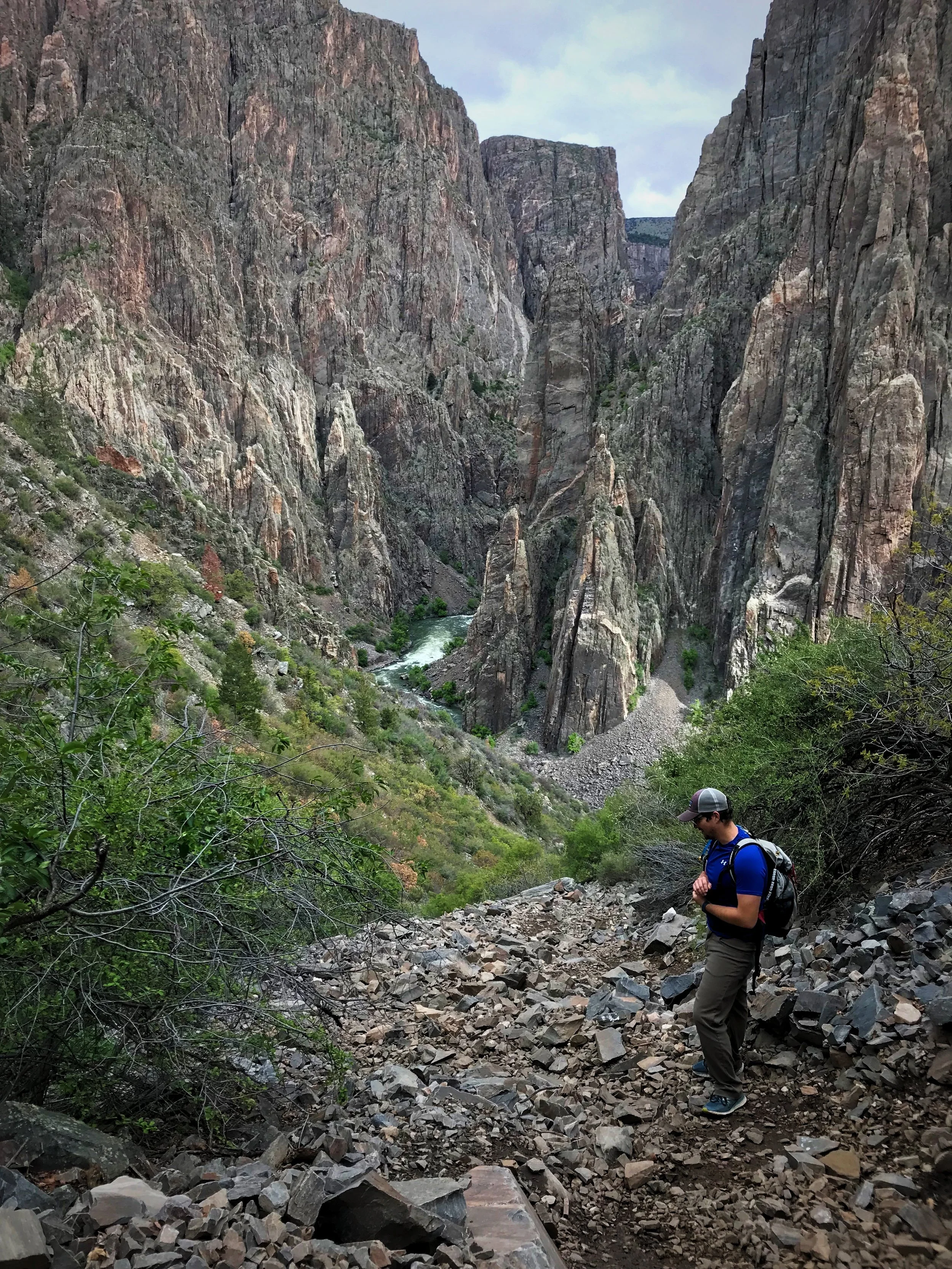
Ian looks down at the scree field near the bottom of the Gunnison Route.

HIking into the Black Canyon is a fun hike if you’re in good shape.

One portion of the hike includes a chain to help you down a loose section of the route.
Planning Your Gunnison Inner Canyon hike
Ian and I knew we wanted part of our Black Canyon of the Gunnison National Park trip to be hiking into the inner canyon, but we weren’t sure which route down the canyon that we wanted to take. We headed to the South Rim Visitor Center, where we talked to Ranger Paul, who gave us a super detailed and helpful orientation to the inner canyon routes. They even have a binder with photos of the routes that they will go through with you. The ways to access the inner canyon are called routes not trails, because the National Park Service does not actively maintain any routes into the canyon. The park service writes, “Hikers are expected to find their own way to be prepared for self rescue.”
On the South Rim, where we were, there are three routes—the Warner Route, the Gunnison Route, and the Tomichi Route. The Tomichi Route is a scree field almost all the way down the canyon. The Warner Route is the the longest, around seven miles round trip, because you must first hike the Warner Point trail to access it. We decided to take the Gunnison Route, which is the most popular and “easiest” route.

At the visitor center, a staff member will talk through a detailed description of the route to help you understand what you are getting into.

A small day pack is perfect for taking on the Gunnison Route. Anything bulkier could be a bit unwieldy while descending.
Although the Gunnison Route is the most popular route, it is still rather strenuous. We picked this one because it’s recommended as a first-time inner canyon hike. It is about three miles round trip, with one mile of descent. In that mile, you will drop 1800 feet in elevation. Ranger Paul told us, “This is not like the Grand Canyon. You are literally descending straight down the canyon walls.” After hiking it, we felt that the Gunnison Route was well within our capabilities, but we sure to evaluate your personal fitness before attempting any inner canyon hike.
The park service recommends bringing a gallon of water per day, but unless it’s hot, you probably don’t need this much water because the Gunnison Route likely won’t take a full day. We each brought two quarts of water in reservoirs and hydration packs. We didn’t drink nearly all of the water we brought. As a back up bring a water filter or some Aquamira water treatment drops so that you could purify water from the river if you need more. Besides water, bring some high-energy snacks and a small first aid kit in a day pack. It’s not a bad idea to bring a good quality rain jacket as well because unexpected storms are common here.

The light on the canyon walls can be really pretty from within the canyon.

Cairns will lead you down the Gunnison Route, but there is no maintained trail down the canyon walls.

There are some really interesting spires and rock formations at the bottom of the canyon.
Wilderness Permits for the gunnison Canyon
Hiking in the inner canyon requires a wilderness permit, and only 15 permits are provided per day on the Gunnison Route. Because of the permitting process, unlike most national parks, you can be guaranteed that you will have a certain amount of solitude on this hike. The permits are provided on a first-come, first-serve basis, so you will want to get there in the morning to get a permit. To get a permit, we camped just outside the park on BLM land—see the end of this article for our site recommendation. We were in the park by 7 am. We are breakfast in our van after we snagged a permit at the “self-serve” permit station, right outside the visitor center. It was late May but it was kind of a rainy day so I think we were the first ones of the day to get a permit.

This is pretty typical of the slope of the Gunnison Route. The elevation drops about 1800 feet in a mile.

Even though it had rained the night before, we found that the Gunnison Route was not too slippery.
Getting Started on the gunnison route
To start the Gunnison Route, you have to access it via the Oak Flat Loop Trail. Take the right side (canyon side) of the Oak Flat Loop for a half mile. The Oak Flat Trail leads you through a lush green aspen grove. The name Oak Flat is kind of deceiving because even this early part of the trail is a series of fairly steep switchbacks. After a few of these switchbacks, you will come across a wilderness sign that says “Permit Required.” There is a pretty defined path off to the right of this sign. This is where the Gunnison Route begins. The route starts as a series of steep dirt switchbacks. This part is actually pretty easy, but don’t let it fool you, because the switchbacks end pretty quickly.
Soon you are basically descending straight down a drainage into the canyon. On this section, there are large boulders and roots to scramble over or really loose rocks here it’s easy to lose your footing. It’s mostly dirt on this first part though. Even though it had rained heavily the night before, the soil wasn’t too slick.

The first portion of the hike is on the Oak Flat Loop, which goes through a lush aspen grove.

The Oak Flat Loop isn’t flat, but it will be the easiest part of the Gunnison Route.

After the Oak Flat trail, the trail is a series of steep switchbacks with rocks and roots to step over.
The Infamous Chain on the gunnison route
About 1/3 of the way down the Gunnison Route there is a long chain, which you can grasp onto to help lower yourself down a steep part of the trail. Oddly enough, this part of the trail with the chain did not actually seem like the steepest part of the route. We could have definitely descended this part of the trail without the assistance of the chain. The chain was pretty cold though, so gloves might have been nice here.

Ian uses the chain to get down a steep part of the trail.

Tug of War with the Black Canyon.

The rope is apparently 80 feet long, but it seemed to us that it was much longer.
After the chain, it’s more going straight down areas of loose dirt trail. Although this is only a route, the trail is marked by small cairns—you have to be careful not to be overly reliant on these though, because they are placed by other hikers and not by the National Park Service. We were sure to keep looking behind us to take mental snapshots, because we had been told it’s harder to find your way back up than down. We wanted to make sure we knew what to look for while climbing back up.
How bad is the Scree on the Gunnison Route?
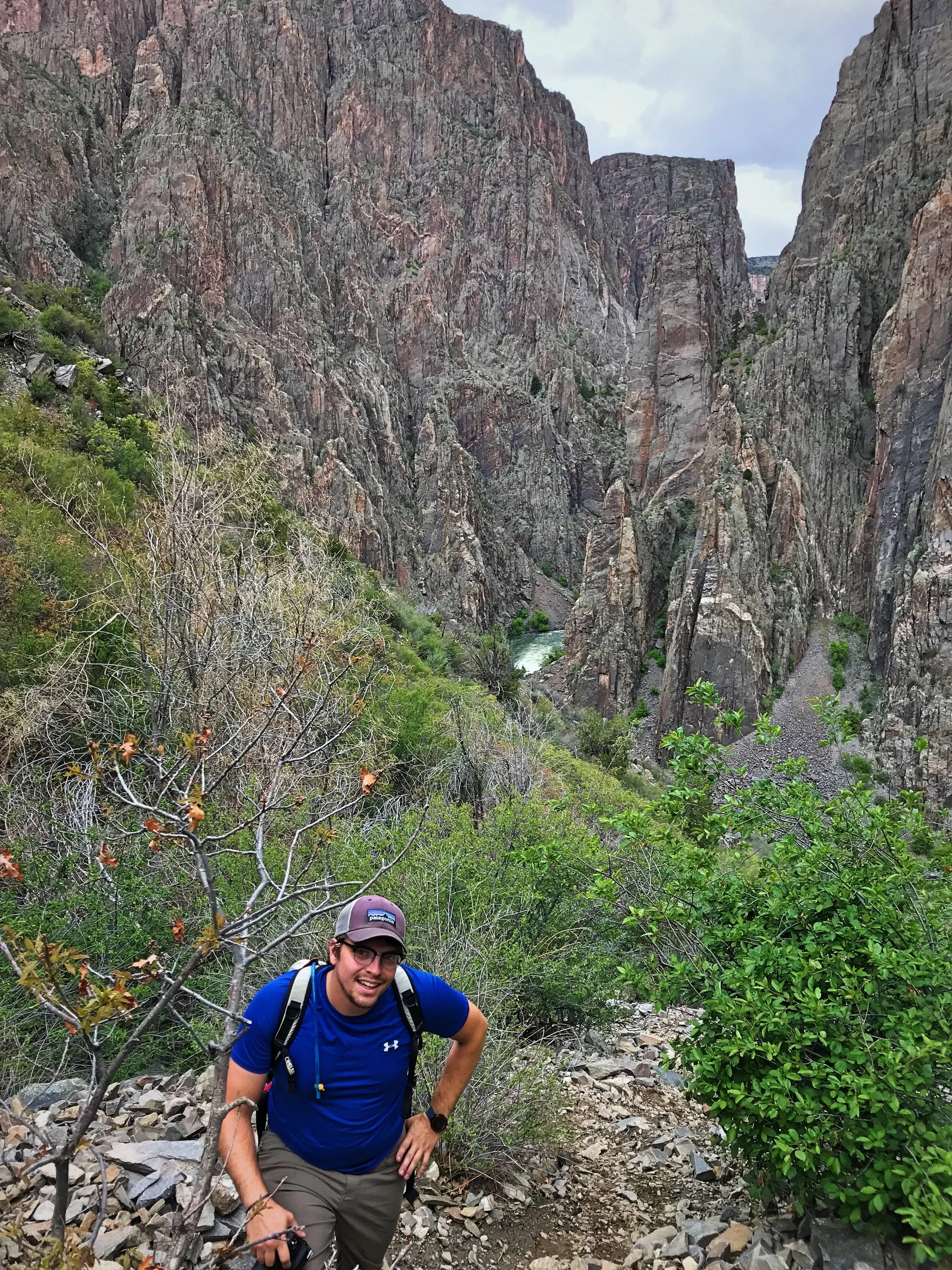
The final third of the Gunnison Route is a descent down a scree field—basically a bunch of loose rock of varying sizes. For us, it wasn’t actually that difficult to walk on, but it was a bit hard on the joints since it was so unstable. It was definitely kind of slow going heading down. Fortunately for me since I have a mild fear of heights, there was very little exposure on the hike. It’s very steep, but there are no spots where it feels like you are going to fall off the edge of a cliff. There was only one spot where I felt even a bit nervous—a short scramble down a 70-degree chunky rock face with tons of handholds. I don’t think Ian even thought twice about it. Near the river the route in the scree field mellows a bit and you get some really great views of the canyon since there is very little tree cover.

The size of the rocks varies significantly in the final portion of the Gunnison Route.

Climbing up the scree is significantly easier that going down it. You can see how it could be a bit difficult to find your way back up.

Ian examines the scree field to figure out the best way to descend. You get excellent views on this final stretch of the Gunnison Route.
The Gunnison River
Once the route deposited us down by the roiling green Gunnison River. We took a rest and a snack break. Towering and regal Ponderosa Pines grow in the canyon bottom along with gnarled Gambrel Oak. Also apparently growing in the canyon is a plethora of poison ivy, which can grow up to five feet tall. Fortunately in late May, the plants were still very small and avoidable. Down at the bottom, there are also three campsites and a pit toilet—in case you feel like hauling a loaded pack down Colorado’s steepest canyon. With our cozy van less than a mile and a half a way, backpacking the Gunnison Rote wasn’t too appealing to us.

A tall Ponderosa Pine on the floor of the Black Canyon of the Gunnison.

The river was running really high while we were in the Black Canyon of the Gunnison.
We were surprised by how loud the river was at the bottom. It was the middle of snowmelt, and the river can be dangerous. The river was flowing at around 4600 CFS. It was not the kind of place where you’d want to go for a swim. At low water, you can walk about 3/4 of a mile along the river, but at high water we definitely couldn’t walk that far before the water abutted against steep rocks that we couldn’t pass easily.

Because the Gunnison River was so high that we couldn’t walk very far on the canyon floor.

It’s really cool to see the towering canyon walls from below. This is some of the world’s oldest exposed rock.
The Climb up the Gunnison Route
The climb back up the canyon was actually a lot easier. It’s very tiring, but technically it’s easier to keep your footing while climbing. We didn’t have any trouble finding our way back, but we did see a few social trails where people might get off into some side gullies.
It took us about three hours to do the hike—1.5 hours to descend, a half hour of hanging out at the bottom, and an hour to climb back out. When we got back we were pretty tired, but we both agreed that difficulty of the hike may have been a bit overstated.

In areas with loose rock and dirt were significantly easier to climb up than down.

This photo shows how steep the majority of the Gunnison Route is.
The climb back up the Gunnison Route is very tiring, but it was faster going up than down.
How Does the Gunnison Route Compare to Other Hikes
The Gunnison Route is challenging and you definitely want to be in good physical shape, but it’s certainly not the most strenuous hike we’ve experienced. So how does the Gunnison Route compare to other popular hikes? It’s less scary than Angels Landing or Half Dome, because there are fewer drop offs and less exposure. It’s nothing like hiking down into the Grand Canyon, where there is a highly developed, wide trail with easy switchbacks. There is less elevation gain/loss than most mountain hikes, but it is over a shorter length of trail. The Gunnison Route was a lot easier and less sketchy than the unmaintained route we took up Observation Mountain while backpacking in the Yukon. Plus there are no grizzly bears in the Black Canyon!

The Gunnison Route is pretty steep, but there are no places where you are walking along a cliff or a narrow ledge.

Since the Black Canyon of the Gunnison National Park doesn’t have many developed hiking trails, taking on one of the inner canyon routes is a good way to experience more of the canyon.
Heading down the Gunnison Route into the Black Canyon is a really great way to spend a morning in the park. It’s definitely a doable hike, so don’t let the fact that it’s an unmaintained route scare you off from trying it, if it’s something you want to do.
Free Camping Near the Black Canyon of the Gunnison National Park
If you are doing an inner canyon route and want to get up early, it’s really convenient to camp right outside the park. There is a small area of BLM land only about three miles from the park entrance. There aren’t a ton of spots, so you may want to arrive early in the afternoon. Also if it rains at all do not drive beyond the entrance of the camping area, because the ground turns to the most slippery mud we’ve ever seen. We even saw a couple people who were stuck at their campsite that was further down the narrow road.

There is a pretty great spot for free camping right outside the entrance to the South Rim of the Black Canyon of the Gunnison National Park.

This is the spot on BLM land outside the park. We couldn’t drive very far in though because it was extremely muddy.
Posts Also Tagged:
Black Canyon of the Gunnison, BLM Land, Canyons, Colorado, Colorado River, Free Camping, Frugal travel, Geology, Gunnison River, Gunnison Route, Hiking, Mountains, National Parks, Oak Flat Loop, Painted Wall, Photography, Public Land, Tomichi Route, trails, Travel, Trees, Warner Route, Wilderness
Have you visited the Black Canyon of the Gunnison National Park? Or hiked an inner canyon route? Leave us your suggestions in the comments below.